2

5


SOUTH ROANOKE from weatherroanoke.com

1

NORTH ROANOKE Image below courtesy of WDBJ Channel 7 - CLICK HERE

North Roanoke


Custom

Surface

Maps:

(generated at this site)


Roanoke, Virginia - photo above courtesy of Instacam (click on link)

Local Private Station Report

Click HERE for station page
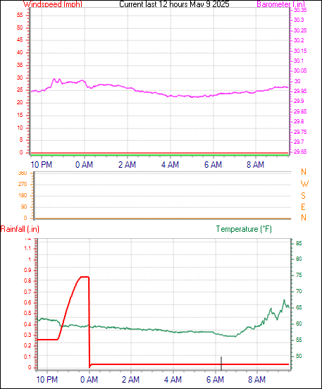
11:30 AM ET 3/31/2026

Located 7 mi. south KROA (South Roanoke)

73.1°F

WIND

15.9 mph SW

Dew Pt./Hum.

52.3°F

48

GUST (hr.)

29.8 mph NW

at 10:37 AM

Rain

Hour  0.00

Day  0.00 in.

PRESSURE

30.280 in.

-0.010in./hr

Hi/LoTemp: 73.1°F/51.8°F


Report from nearest NOAA/FAA station
KROA - ROANOKE AIRPORT, 7 mi. N

  Click for the latest Roanoke weather forecast.


Visible Satellite Photo


vis satellite


Infrared Satellite Photo


IR satellite


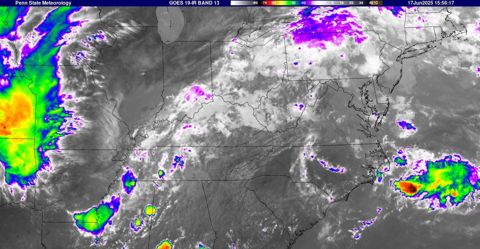
WATER VAPOR LOOP - CLICK HERE


wv satellite

LIGHTNING MAP

Looking for new source


 FORECASTS:

National Weather Service Forecast for: Roanoke VA
Issued by: National Weather Service Blacksburg, VA
Updated: 10:01 am EDT Mar 31, 2026

Roanoke, VA
 
Today

Today: Mostly sunny, with a high near 82. Southwest wind 9 to 13 mph, with gusts as high as 21 mph.
Mostly Sunny

Tonight

Tonight: Mostly clear, with a low around 60. Southwest wind 6 to 9 mph.
Mostly Clear

Wednesday

Wednesday: Showers likely and possibly a thunderstorm after 2pm.  Increasing clouds, with a high near 84. Southwest wind 5 to 9 mph.  Chance of precipitation is 60%. New rainfall amounts of less than a tenth of an inch, except higher amounts possible in thunderstorms.
Mostly Sunny
then Showers
Likely
Wednesday
Night
Wednesday Night: Showers and thunderstorms likely before 11pm, then a chance of showers between 11pm and 2am.  Mostly cloudy, with a low around 60. South wind around 6 mph becoming calm  in the evening.  Chance of precipitation is 60%. New precipitation amounts of less than a tenth of an inch, except higher amounts possible in thunderstorms.
Showers
Likely then
Chance
Showers
Thursday

Thursday: A chance of showers after 2pm.  Mostly sunny, with a high near 84. Light southwest wind becoming south 8 to 13 mph in the afternoon.  Chance of precipitation is 30%.
Mostly Sunny
then Chance
Showers
Thursday
Night
Thursday Night: A chance of showers before 8pm.  Partly cloudy, with a low around 59. Chance of precipitation is 30%.
Chance
Showers then
Partly Cloudy
Friday

Friday: A chance of showers and thunderstorms after 2pm.  Partly sunny, with a high near 82. Chance of precipitation is 40%.
Partly Sunny
then Chance
T-storms
Friday
Night
Friday Night: A chance of showers and thunderstorms before 8pm.  Mostly cloudy, with a low around 59. Chance of precipitation is 30%.
Chance
T-storms then
Mostly Cloudy
Saturday

Saturday: A chance of showers after 2pm.  Mostly sunny, with a high near 83. Chance of precipitation is 40%.
Mostly Sunny
then Chance
Showers
Hi 82 °F Lo 60 °F Hi 84 °F Lo 60 °F Hi 84 °F Lo 59 °F Hi 82 °F Lo 59 °F Hi 83 °F


Today
 
Mostly sunny, with a high near 82. Southwest wind 9 to 13 mph, with gusts as high as 21 mph.
Tonight
 
Mostly clear, with a low around 60. Southwest wind 6 to 9 mph.
Wednesday
 
Showers likely and possibly a thunderstorm after 2pm. Increasing clouds, with a high near 84. Southwest wind 5 to 9 mph. Chance of precipitation is 60%. New rainfall amounts of less than a tenth of an inch, except higher amounts possible in thunderstorms.
Wednesday Night
 
Showers and thunderstorms likely before 11pm, then a chance of showers between 11pm and 2am. Mostly cloudy, with a low around 60. South wind around 6 mph becoming calm in the evening. Chance of precipitation is 60%. New precipitation amounts of less than a tenth of an inch, except higher amounts possible in thunderstorms.
Thursday
 
A chance of showers after 2pm. Mostly sunny, with a high near 84. Light southwest wind becoming south 8 to 13 mph in the afternoon. Chance of precipitation is 30%.
Thursday Night
 
A chance of showers before 8pm. Partly cloudy, with a low around 59. Chance of precipitation is 30%.
Friday
 
A chance of showers and thunderstorms after 2pm. Partly sunny, with a high near 82. Chance of precipitation is 40%.
Friday Night
 
A chance of showers and thunderstorms before 8pm. Mostly cloudy, with a low around 59. Chance of precipitation is 30%.
Saturday
 
A chance of showers after 2pm. Mostly sunny, with a high near 83. Chance of precipitation is 40%.
Saturday Night
 
A chance of showers before 8pm. Partly cloudy, with a low around 60. Chance of precipitation is 30%.
Sunday
 
Showers likely. Partly sunny, with a high near 78. Chance of precipitation is 60%.
Sunday Night
 
Showers likely. Mostly cloudy, with a low around 46. Chance of precipitation is 60%.
Monday
 
A chance of showers. Mostly sunny, with a high near 63. Chance of precipitation is 30%.


Forecast from NOAA-NWS for Roanoke VA.


ZONE FORECAST - Issued by local NWS office:

Expires:202603312200;;593121
FPUS51 KRNK 311405
ZFPRNK

Zone Forecast Product for Virginia
National Weather Service Blacksburg VA
1003 AM EDT Tue Mar 31 2026


VAZ022-312200-
Roanoke-
Including the cities of Roanoke and Salem
1003 AM EDT Tue Mar 31 2026

.THIS AFTERNOON...Mostly sunny. Highs in the upper 70s. Southwest
winds 10 to 15 mph with gusts up to 30 mph. 
.TONIGHT...Partly cloudy in the evening, then becoming mostly
clear. Lows around 60. Southwest winds 10 to 15 mph with gusts up
to 25 mph. 
.WEDNESDAY...Mostly sunny. Showers likely with a chance of
thunderstorms in the afternoon. Highs in the lower 80s. Southwest
winds 5 to 10 mph with gusts up to 25 mph. Chance of rain
70 percent. 
.WEDNESDAY NIGHT...Mostly cloudy with showers likely with a
chance of thunderstorms in the evening, then partly cloudy with a
chance of showers after midnight. Lows in the upper 50s.
Southwest winds 5 to 10 mph. Chance of rain 70 percent. 
.THURSDAY...Mostly sunny. A chance of showers in the afternoon.
Highs in the lower 80s. South winds 10 to 15 mph with gusts up to
25 mph. Chance of rain 30 percent. 
.THURSDAY NIGHT...Partly cloudy. A chance of showers in the
evening. Lows in the upper 50s. Chance of rain 30 percent. 
.FRIDAY AND FRIDAY NIGHT...Mostly cloudy. A chance of showers and
thunderstorms. Highs in the upper 70s. Lows in the upper 50s.
Chance of rain 40 percent. 
.SATURDAY...Mostly sunny. A chance of showers in the afternoon.
Highs in the lower 80s. Chance of rain 50 percent. 
.SATURDAY NIGHT...Mostly cloudy in the evening, then becoming
partly cloudy. A chance of showers. Lows in the lower 60s. Chance
of rain 50 percent. 
.SUNDAY AND SUNDAY NIGHT...Mostly cloudy. Showers likely. Highs
in the mid 70s. Lows in the mid 40s. Chance of rain 60 percent. 
.MONDAY...Partly sunny with a 30 percent chance of showers.
Cooler with highs in the lower 60s. 

$$


SPECIAL WEATHER STATEMENTS/WARNINGS
Last warning issued:
%NOAAEvent2=%vaz022.txt

VAZ022.

This weather web site is operated to provide additional weather data. Every effort is made to update the data on

regular basis but there may be occasions when equipment downtime or other factors will affect that effort.

Weatherdata is believed to be accurate for the area where sensors are located. However, no guarantees are

associated with that information. When making important weather related decisions NEVER depend on weather

information from this web site.... or any web site(s) other than those operated by the National Weather Service.

CLICK HERE to email site manager